


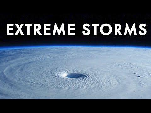
When the sky darkens, winds howl, and rain begins to hammer against your windows in relentless sheets, you are witnessing one of nature’s most powerful displays — a big storm. These massive weather events reshape coastlines, disrupt economies, and test the resilience of entire communities. Whether you are a homeowner bracing for hurricane season, a traveler monitoring severe weather alerts, or simply someone fascinated by the raw force of the atmosphere, understanding big storms is more than academic curiosity. It is a matter of safety, preparedness, and respect for the planet’s most violent atmospheric phenomena. In this comprehensive guide, we will dive deep into what makes storms become truly massive, explore the different categories of destructive weather systems, unpack the science behind their formation, and give you practical, actionable advice for preparing and recovering when these events strike.
What Are Big Storms? Defining the Scale of Atmospheric Fury
A big storm is not simply rain or wind that feels uncomfortable. Meteorologists classify major storm systems based on wind speed, spatial extent, duration, and the level of destruction they can produce. The term encompasses everything from sprawling tropical cyclones that span hundreds of miles to violent mesoscale convective systems capable of spawning dozens of tornadoes in a single day. What sets these events apart is their ability to cause widespread infrastructure damage, long-term power outages, and sometimes catastrophic loss of life. Understanding the scale and classification of these storms helps emergency responders allocate resources and gives communities the knowledge they need to take appropriate protective action before landfall or impact.

Types of Big Storms Around the Globe
Not all big storms look the same, and their behavior varies dramatically depending on geographic location, season, and atmospheric conditions. Below, we break down the most significant storm categories that meteorologists and emergency managers track year-round.
Hurricanes and Typhoons — Tropical Cyclones That Dominate Coastlines
Hurricanes, typhoons, and cyclones are all the same type of storm system — tropical cyclones — named differently depending on where they occur. Hurricanes form in the Atlantic and northeastern Pacific, typhoons in the western Pacific, and cyclones in the Indian Ocean and South Pacific. These storms draw energy from warm ocean water, often reaching sustained wind speeds exceeding 150 mph. Category 4 and Category 5 hurricanes, such as Hurricane Katrina in 2005 and Typhoon Haiyan in 2013, represent the most extreme examples of tropical cyclone intensity. Their storm surges alone can push ocean water miles inland, flooding coastal cities within hours.
Tornadoes and Supercell Thunderstorms
While tropical cyclones cover vast areas, tornadoes are the pinpoint weapons of the storm world. A single supercell thunderstorm can produce an EF5 tornado with winds exceeding 200 mph, capable of leveling reinforced structures. Tornado Alley in the central United States sees the highest frequency of these violent vortexes, but big storm outbreaks have occurred on every inhabited continent. What makes supercells particularly dangerous is their rotating updraft, called a mesocyclone, which can sustain the tornado for hours and produce hail the size of baseballs along the way.
Nor’easters and Major Winter Blizzards
Big storms are not limited to warm weather. Nor’easters are intense low-pressure systems that slam into the northeastern United States, bringing sustained gale-force winds, heavy snow, and coastal flooding. The Blizzard of 1996 and the 2021 Texas winter storm are recent reminders that cold-season systems can be just as devastating as their tropical counterparts. These storms often stall along the coast, drawing moisture from the Atlantic and dumping rain or snow for days on end.
How Big Storms Form — The Science Behind the Chaos
The formation of a major storm system requires a precise combination of ingredients. For tropical cyclones, forecasters look for sea surface temperatures of at least 26.5°C (80°F), low vertical wind shear, and sufficient Coriolis force to initiate rotation. For severe thunderstorms and tornadoes, the atmosphere needs strong instability, ample moisture, and a lifting mechanism such as a cold front or dry line. When these ingredients converge, the result can be explosive intensification — a storm that goes from a minor disturbance to a life-threatening event in a matter of days.

Climate scientists are now observing that climate change is amplifying several of these formation factors. Warmer ocean temperatures are fueling more intense hurricanes, while shifting jet stream patterns are causing some storm systems to slow down and linger longer over affected areas. This means communities that historically rarely experienced major storms are now facing increased risk, making public awareness and infrastructure investment more critical than ever.
Comparing the Most Destructive Storm Categories
To understand the relative danger of different storm types, it helps to compare them side by side. The following table outlines key characteristics of the most destructive big storm categories.
| Storm Type | Peak Wind Speed | Duration | Primary Damage Cause | Warning Time |
| Category 5 Hurricane | Over 157 mph | Days to weeks | Storm surge, wind, flooding | 3–5 days |
| EF5 Tornado | Over 200 mph | Minutes to hours | Extreme wind damage | Minutes |
| Major Nor’easter | 70–90 mph | 1–3 days | Snow, ice, coastal flooding | 2–4 days |
| Derecho Wind Storm | 100+ mph | Hours to days | Straight-line wind damage | 1–2 days |
| Tropical Cyclone (Cat 3–5) | 111–157+ mph | Days | Storm surge, rainfall | 2–5 days |
This comparison table highlights a critical point: warning time varies enormously between storm types. Hurricanes give residents days to evacuate or secure their property, while tornadoes may provide only minutes of advance notice. Understanding these differences shapes how you prepare for each type of event.

Preparing for Big Storms — Expert Tips That Actually Work
Storm preparedness is not about panic buying or last-minute scrambles. It is about building a systematic storm readiness plan that your household can execute calmly when warnings are issued. Here are the steps that emergency management professionals consistently recommend.
- Build a 72-hour emergency kit including water, non-perishable food, medications, flashlights, batteries, a hand-crank radio, and important document copies.
- Know your evacuation zone. Check local flood maps and identify multiple routes out of your area before storm season begins.
- Reinforce your home. Install storm shutters, reinforce garage doors, trim trees near your property, and seal gaps where water can enter.
- Back up digital data and charge all portable devices. Consider a portable generator or solar battery bank for extended power outages.
- Establish a family communication plan so every member knows where to meet and how to check in if cellular networks go down.
One expert tip that many people overlook is to photograph or video your property before storm season. This documentation is invaluable for insurance claims when damage occurs. Additionally, consider purchasing flood insurance separately from your homeowner’s policy, as most standard policies do not cover storm surge or river flooding.
The Aftermath: Recovery and Rebuilding After Major Storm Events
Once the winds die down and the floodwaters recede, the real work begins. Storm recovery is a complex, often months-long process that involves structural repairs, insurance claims, mental health support, and community rebuilding. FEMA and local emergency management agencies typically deploy resources in the aftermath of a federally declared disaster, but wait times can be significant. Homeowners who document their damage thoroughly and file claims promptly tend to recover faster. Community resilience also plays a huge role — neighborhoods with pre-established mutual aid networks and volunteer organizations recover with remarkable speed compared to those relying solely on external assistance.
Frequently Asked Questions About Big Storms
What is the difference between a hurricane watch and a hurricane warning?
A hurricane watch means that hurricane conditions are possible in your area within 48 hours, signaling that you should begin preparations. A hurricane warning means sustained winds of 74 mph or higher are expected within 36 hours, and you should be executing your evacuation or shelter-in-place plan immediately. The distinction matters because it determines your window of action.
Can a big storm cause damage far inland from the coast?
Absolutely. While coastal areas face the most immediate threat from storm surge, major hurricanes and tropical systems routinely cause catastrophic flooding and wind damage hundreds of miles inland. Remnants of hurricanes that have moved over land have triggered deadly flash floods in states far from the Atlantic or Gulf coast. The 2021 remnants of Hurricane Ida, for example, caused devastating flooding in Pennsylvania and New Jersey.
What should you do if you are caught outside during a severe thunderstorm?
If you are outdoors and a severe thunderstorm with big gusts approaches, seek shelter immediately in a sturdy building or hard-topped vehicle. Avoid open fields, tall isolated trees, metal structures, and bodies of water. If no shelter is available, crouch low to the ground in a dense cluster of small trees, keeping your hands on your knees and minimizing your contact with the earth.
How do climate trends affect the frequency of big storms?
Research indicates that while the total number of tropical cyclones globally may not increase significantly, the proportion of high-intensity Category 4 and 5 hurricanes is expected to grow as ocean temperatures rise. Additionally, storms are intensifying more rapidly, giving communities less time to prepare. Climate models also suggest that storm systems will carry more moisture, leading to heavier rainfall and increased inland flooding risks in many regions.
What is the safest room in a house during a tornado?
The safest location is a basement or storm cellar below ground level. If a basement is unavailable, go to the lowest floor and shelter in an interior room with no windows — a bathroom, closet, or hallway. Get under a sturdy piece of furniture and cover your body with a mattress or heavy blankets to protect against flying debris. Mobile homes are extremely dangerous during tornadoes; residents should evacuate to a nearby reinforced shelter before warnings are issued.
Final Thoughts on Understanding and Surviving Big Storms
Big storms are among the most powerful forces on Earth, and their impact will only grow as the climate continues to evolve. Knowledge is your greatest asset — understanding how these systems form, how they are classified, and what steps you can take to protect yourself and your property transforms you from a passive observer into an active participant in your own safety. Whether you live in a hurricane-prone coastal zone, the tornado belt of the Great Plains, or a region that rarely sees severe weather, preparedness is not optional. It is essential. Stay informed, stay connected, and remember that the storm will pass, but the preparation you make today could save your life tomorrow.